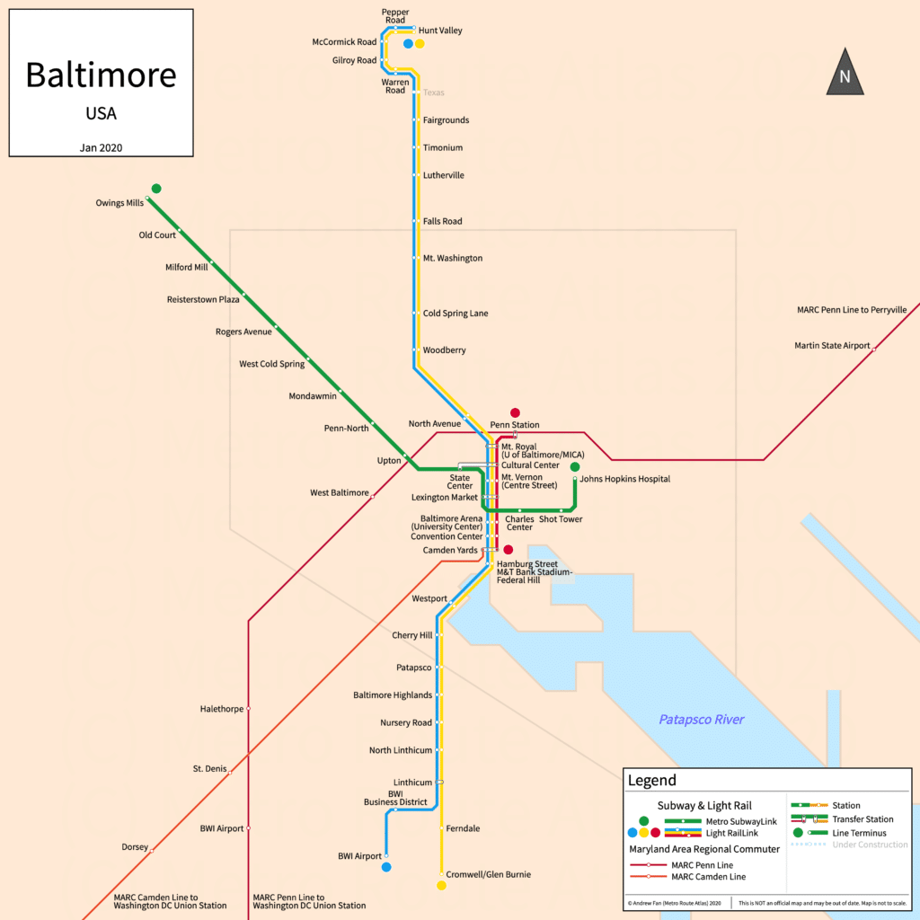
Baltimore Light RailLink Map
The Baltimore Light RailLink is an essential part of Baltimore’s public transit system, providing reliable and affordable transportation throughout the metropolitan area. With three main lines—the Blue Line, Yellow Line, and Red Line—Light RailLink allows riders to access key destinations, major transportation hubs, and attractions in Baltimore.
Baltimore Light RailLink
The Baltimore Light RailLink system offers coverage across Baltimore with connections to BWI Marshall Airport, Camden Yards, Penn Station, and other essential destinations. The system is managed by the Maryland Department of Transportation Maryland Transit Administration (MDOT MTA) and features a convenient route map designed for both residents and visitors.
Key Highlights of the Baltimore Light RailLink System:
- Lines: Blue Line, Yellow Line, and Red Line
- Main Destinations: BWI Marshall Airport, Hunt Valley, Timonium, Penn Station, and Camden Yards
- Transit Connections: MARC Train, Amtrak, Metro SubwayLink, and numerous bus routes
- Total Stations: Over 30 stations
Baltimore Light RailLink Map
The Baltimore Light RailLink map visually represents the routes, stations, and key points along each line. Whether you’re heading to work, exploring the city, or catching a game at Camden Yards, the map provides a comprehensive guide to the Light RailLink system.
Light RailLink Routes and Lines
1. Blue Line
The Blue Line connects Hunt Valley to BWI Airport, covering over 28 stations. This route is perfect for travelers needing quick access to the airport or key locations like Mt. Vernon and the Cultural Center.
2. Yellow Line
The Yellow Line runs between Timonium and Cromwell/Glen Burnie, serving 30 stations and covering popular locations, including Lexington Market and Camden Yards.
3. Red Line
The Red Line is the shortest route, running between Penn Station and Camden Yards. This line is ideal for quick trips within central Baltimore and for connecting with major regional transit hubs like Amtrak and MARC at Penn Station.
Using the Baltimore Light RailLink Map
The Light RailLink map shows each station, connection, and transfer point along the system's three lines. Riders can use the map to plan journeys by identifying transfer points between the lines or at key intersections for MARC Trains, Amtrak, and Metro SubwayLink.
Popular Destinations on the Baltimore Light RailLink
- BWI Marshall Airport: Direct access via the Blue Line from central Baltimore, making travel to and from the airport simple and affordable.
- Camden Yards: Home of the Baltimore Orioles, this stadium is accessible via the Blue and Yellow Lines.
- Penn Station: Baltimore’s major transit hub, with access to Amtrak and MARC, making regional and national travel connections easy.
- Lexington Market: A historic Baltimore market accessible via the Yellow and Red Lines.
Benefits of the Baltimore Light RailLink System
- Affordable Travel: At a low fare of $2.00 per ride, Light RailLink provides a cost-effective option for navigating Baltimore.
- Convenient Transfers: Access to MARC, Amtrak, Metro SubwayLink, and local bus services make the system versatile for all transit needs.
- Environmentally Friendly: Light rail transit offers a greener alternative to driving, reducing emissions and traffic congestion in Baltimore.
Frequently Asked Questions
1. How do I find the Light RailLink map?
The official MDOT MTA website offers an interactive Light RailLink map for riders.
2. Is the Baltimore Light RailLink map accessible at stations?
Yes, most Light RailLink stations have maps available, and many also feature signage to guide riders.
3. Can I use one ticket across all Light RailLink lines?
Yes, a single fare allows access to all lines, with free transfers within the Light RailLink system.
The Baltimore Light RailLink map is a helpful tool for navigating the city’s transit system, allowing riders to access key destinations, connections, and services with ease.


Leave a Reply